ConferenceSeries Ltd all the participants across the globe to attend the "2nd International Convention on Geophysics and Geotechnics" during November 8-9, 2017 at Las Vegas, USA that includes prompt keynote presentations, Oral talks, Poster presentations and Exhibitions.
Meet Inspiring Speakers and Experts at our 1000+ Global Events inclusive of 300+ Conferences, 500+ Workshops and 200+ Symposiums every year on Pharma, Medicine, Clinical, Engineering and Earth & Environmental Science.
Geophysics-2017 aims to place a forum where the foremost academic scientists, geologists, geophysicists, young researchers from all over the world together where they will to exchange and share their experiences and research results. The conference will be the leading forum for all recent advancements in geology and geosciences. It will promote the science of geology the eminent professionals of geology from all over the world. The important features of this conference are well organized workshops, events and symposia, poster presentations and world class exhibits, panel discussions & interactive sessions, collaborative research opportunities.
A huge gathering of academic scientists, geophysicists, geologists, young researcher, Professors, Research Scientists and students of different Universities containing Geological studies will be at Geophysics-2017. Also the eminent persons of different Geological Association and Societies, Directors, CEOs, Managers of different companies related to geology from all over the world will meet to share their research and knowledge at conference.
We look forward to an exciting scientific event in the city of Las Vegas, USA
1. Magnetic and Gravity Methods:
Magnetic geophysical surveys measure small, localized variations in Earth’s magnetic field. The magnetic properties of naturally occurring materials such as basic igneous rocks allow and magnetic ore bodies them to be identified and mapped by magnetic surveys. Anomalies or Strong local magnetic fields are also produced by buried steel objects. Magnetometer surveys find underground storage drums, tanks, piles and reinforced concrete foundations by detecting magnetic anomalies they produce. The goal of studying detailed gravity data is to provide a better understanding of subsurface geology. The gravity method is a relatively on-invasive, cheap, on-destructive remote sensing method. It's also passive that is, no energy need be put into ground in order to acquire data, and thus, method is well suited to a populated setting. The small portable instrument used also permits walking traverses. Measurements of the gravity provide information about densities of rocks underground. There is a wide range in density among rock types, so geologists can make inferences about distribution of strata. The gravity method involves measuring gravitational attraction exerted by earth at a measurement station on the surface
-
Physical Preliminary
-
Gravitation Radius
-
Measurements of Gravity and Magnetism
-
Anomalies and Discrepancies
-
Magnetic Surveying and Instruments
-
Magnetic Field Intensity and Effects
-
Origin of Magnetic Field and Fluxes
-
Motors and Summary
-
Gravity and Exploration Methods
-
Laws and Motions of Gravity
-
Electron Magnetic Force
-
Magnetic Exploration Methods
-
Data Display and Anomalous Enhancements
2. Global Geophysics:
It is an intriguing field. The review runs with the Earth utilizing gravity, attractive, electrical, and seismic techniques, which announce the component of the Earth. It is basically used to recognize, outline foresee the nearness and potential development of surface water and groundwater and to distinguish contaminants in the dirt dampness inside the upper 10 to 50 m of the Earth's surface. Natural geophysics is a connected science worried with the down to earth utilization of the standards of geophysics in the tackling of ecological issues. It incorporates Hydro geophysics, Environmental Mineralogy, Hydro geochemistry, Soil Mechanics etc. The investigation of Environmental Science manages the investigation of environment with the reconciliation of physical science
-
Physical Properties of Rocks
-
Magnetic Susceptibility of Minerals
-
Properties of Elasticity
-
Shear Modules
-
Natural Potentials
-
Geographical Anomalies and Interpretations
-
Isostasy
-
Geophysical Surveying
-
Classifications and Applications of Geophysics
-
Analysis of Geophysics
-
Planetary Geology
3. Mineralogy and Petrology:
Mineralogy is subject of geology specializing in scientific study of crystal structure, chemistry, and physical properties of minerals and the mineralized artifacts. Specific studies within the mineralogy include the processes of formation and mineral origin Petrology is the study of rocks, meteorites and minerals, their occurrence, origin, evolution, composition, evolution of solar system and the interior of planets. Processes involve tectonic movements of masses, injections and volcanic eruptions, solidification and crystallization, melting and recrystallization, sedimentation, weathering, metamorphism, megascopic and microscopic identification of rocks and minerals. The interior structure of Earth from the core, mantle, lithosphere, continental and oceanic crust, hydrosphere, atmosphere to biosphere illustrated along with nebular theory of age and origin. Rocks have been classified into the three major genetic classes, igneous, sedimentary and metamorphic. Theory of plate tectonics for current configuration of Earth lithosphere and component continents with zone of seduction, plate boundaries such as convergent, transform and divergent are discussed. Organics movements through the collision and non-collision are explained.
-
Polymorphism and Isomorphism
-
Chemical and Physical Properties
-
Carbonates and Nitrates
-
Sedimentary Petrology
-
Igneous Rocks and Their Classifications
-
Archaeological Applications
-
Investigation Methods
-
Order of minerals and Classifications
-
Characteristics of Mineralogy
-
Characteristics of petrology
-
Mine Development
-
Western Minerals regions
-
Building Materials
-
Ceramics and Glasses
-
Natural Gemstones
4. Exploration Seismology:
Seismic exploration is use of seismic energy to probe beneath the surface of the earth, usually as an aid in searching for economic deposits of oil, gas or minerals, but also for engineering, archeological and scientific studies. In exploration seismology, the method of seismic is applied at or near the earth's surface to measure the elastic properties of subsurface and to detect variations in those properties. And Variations in subsurface elastic properties may be demonstrative of changes in pore fluids or lithology. Exploration seismology has been applied for subsurface exploration of depths as great as 150 km; it is particularly useful for depths up to 10 km. For these depths, the seismic method is capable of detecting and spatially resolving features at scales as small as less or tens of meters. This resolving power is significantly finer than resolving ability of other remote geophysical methods for this depth regime. Because this region of the earth's subsurface includes nearly all of its gas reserves and oil , exploration seismology plays a prominent role in the energy industry
-
Methods of Seismology
-
Earth Quack Cycle and Predication
-
Global Gravity
-
Types of Waves and Classifications
-
Processing and Sequences of Seismology
-
Resolutions and Interpretations of Seismology
-
Signal Analysis
-
3D Seismic Processing
-
Correlations of Signals
-
Seismic Isolation
-
Microzation and Sites Effects
-
Applications and Case of Histories Of Seismology
5. Tectonics and Crustal Evolution:
Tectonics is the process that controls the structure and properties of the Earth's crust and its evolution through time. In particular, it describes the processes of mountain building, the behavior and growth of the strong, old cores of continents known as crotons, and the also provides a framework for understanding the volcanic belts and earthquake that directly affect much of the global population. These Tectonic studies are important as guides for economic geologists searching for ore deposits of metallic and nonmetallic resources and fossil fuels. An understanding of tectonic principles is fundamental to geomorphologists to explain erosion patterns and other surface features of Earth. The crust is the archive of Earth’s history. Its rock unit’s record events that is heterogeneous in time with distinctive peaks and troughs of ages for igneous crystallization, continental margins, metamorphism, and mineralization. This temporal distribution is argued largely to reflect the different preservation potential of rocks generated in different tectonic settings, rather than fundamental pulses of activity, and peaks of ages are linked to the timing of supercontinent assembly. Elemental data and Isotopic from zircons and whole rock crustal compositions suggest that the overall growth of continental crust has been continuous throughout Earth’s history. A decrease in the rate of crustal growth ca. 3.0 (GA) is related to increase recycling associated with the onset of plate tectonics.
-
Plate Tectonics
-
Earth’s Crust and Types
-
Comparative Planetary Evolution
-
Tectonic Settings
-
Earths mantel and Core
-
Volcanology
-
Origin Crutals
-
Achaean Crustal Evolution
-
Evolving Continents
-
Rock Forming Minerals
-
Oceanic Tectonic
-
Metamorphism and Tectonics
6. Coastal Engineering:
Coastal engineering is a branch of civil engineering concerning the specific demands posed by constructing at or near coast, as well as the development of the coast itself. The hydrodynamic impact of especially waves, tides, storm surges and tsunamis and harsh environment of salt seawater are typical challenges for the coastal engineer as are the morph dynamic changes of the coastal topography, caused both by the autonomous development of system and man-made changes. The areas of interest in coastal engineering include the coasts of the oceans, seas, marginal seas, big lakes and estuaries. Besides building, design and maintenance of coastal structures, coastal engineers are often interdisciplinary involved in integrated coastal zone management, also because of their specific knowledge of hydro- and morph dynamics of the coastal system. This may include providing input and technology for e.g. environmental impact assessment, port development, strategies for coastal defense, offshore wind farms, land reclamation and other energy-production facilities, etc.
-
Design and Planning of Coastal Works
-
Beach Nourishment
-
Coastal morphology
-
Sediment Transport
-
Coastal Structure
-
Waves Currents and sediment Transport
-
Mathematical and Numerical Modeling
-
Near shore Currents
-
Coastal Estuarine and Offshore Morphology
-
Coastal Engineering and Applications
7. Electrical Resistivity:
Surface electrical resistivity surveying is based on the principle that distribution of electrical potential in the ground around a current-carrying electrode depends on electrical resistivities and distribution of the surrounding rocks and soils. Usually practice in the field is to apply an electrical direct current (DC) between two electrodes implanted in the ground and to measure difference of potential between two additional electrodes that don't carry current. Usually, the potential electrodes are in line between the current electrodes, in principle, they can be located anywhere. The current used is direct current, commutated direct current or AC of low frequency (typically about 20 Hz). All analysis and interpretation are done on basis of direct currents. Distribution of potential can be related theoretically to ground resistivity’s and their distribution for some simple cases, notably, case of a horizontally stratified ground and case of homogeneous masses separated by vertical planes. For other kinds of resistivity distributions, interpretation is usually done by qualitative comparison of observed response with that of idealized hypothetical models.
-
Electrode Configuration and Geometric Facts
-
Modes of Development and Interpretation Methods
-
ERT application and Case Histories
-
Resistivity and Applications
-
Schematic Current Flow In Archie and Applications
-
Rock Types and Resistivity values
-
Geometric Facts for Different Configuration
-
Masters Curves and Uses
8. Earthquake:
Earthquake is shaking of the surface of the Earth, resulting from the sudden release of energy in the Earth's lithosphere that creates seismic waves. This can be violent enough to toss people around and destroy whole cities. The seismic activity or seismicity of an area refers to the frequency, type and size of earthquakes experienced over a time of period. At the Earth's surface, earthquakes manifest themselves by sometimes displacement and shaking of the ground. When the epicenter of a large earthquake is located offshore, the seabed may be uprooted sufficiently to cause a tsunami. Earthquakes can also trigger landslides, and occasionally volcanic activity. Volcanic activity.
-
Faults and Effects of Earthquake
-
Earthquake Engineering
-
Ground Motions and Structures
-
Causes of Earthquakes
-
Size and Frequency Occurrence
-
Tsunamis
-
Magnetic Anamclies
-
Classification of Earthquake
-
Earthquakes science
-
Evacuation Plannings
9. Heat Flow and Geothermic:
Heat transfer is the exchange of thermal energy between physical systems. Here the rate of heat transfer is dependent on the temperatures of the systems and properties of the interceding medium through which the heat is exchanged. The three fundamental modes of heat transfer are radiation, convection and conduction. Heat transfer, the flow of energy in the form of heat, is a process by which a system's internal energy is changed, hence is of indispensable use in applications of the First Law of Thermodynamics. Conduction is known as diffusion, not to be confused with diffusion related to the mixing of constituents of a fluid. Geothermal energy is heat energy generated and stored in the Earth. The Thermal energy is the energy that determines the temperature of matter. The geothermal energy of the Earth's crust originates from the original formation of the planet and from the radioactive decay of materials in currently uncertain but possibly roughly equal proportions. The geothermal gradient, which is the difference in temperature between core of the planet and its surface, drives a continuous conduction of thermal energy in the form of heat from the core to the surface. The adjective geothermal originates from the Greek roots, meaning earth, and thermos, meaning hot. Earth’s internal heat is thermal energy generated from radioactive decay and continual heat loss from Earth's formation.
-
Thermal Conductivity and Measurements
-
Transient of Flow of Heat
-
Origins of Geothermal Energy
-
Environmental Effect On Geothermal Energy
-
Classifications of Geothermal Energy
-
Risks of Geothermal
-
Convective of Heat Flow
-
Applications of Geotheramal
10. Soil Mechanism:
Soil mechanics is the branch of soil physics and engineering mechanics that describes the behavior of soils. It differs from solid mechanics and fluid mechanics in the sense that soils consist of a heterogeneous mixture of fluids (usually like air and water) and particles (usually like clay, silt, sand, and gravel) but soil may also contain organic solids and other matter. Along with soil mechanics, rock mechanics provides the theoretical basis for analysis in geotechnical engineering a sub discipline of engineering geology and civil engineering, a sub discipline of geology. It is used to analyze the deformations and flow of fluids within natural and man-made structures that are supported made of soil, or structures that are buried in soils. Example applications are building and bridge foundations, dams, retaining walls, and buried pipeline systems. Principles of soil mechanics are also used in related disciplines such as geophysical engineering, engineering geology, coastal engineering, agricultural engineering, soil physics and hydrology.
-
Floating Caissons
-
Soil Technology
-
Properties and Classifications of Soils
-
Surveying Strength of Soil
-
Development and applications of Soils
-
Residuals and Transient Soils
-
Particle Sicze and Analysis
-
Earth Pressure Theories
-
Stress In Soil Mass
-
Classifications of Soil
-
Capillary Water
-
Unsaturated Properties
11.Geotechnical Engineering:
Geotechnical engineering is that the branch of applied science involved with the engineering behavior of earth materials. Geotechnical engineering is very important in applied science, however conjointly has an application in military, mining, crude and different engineering disciplines that square measure involved with construction occurring on the surface or inside the bottom. Geotechnical engineering uses principles of soil mechanics and rock mechanics to analyze belowground conditions and materials; confirm the relevant physical/mechanical and chemical properties of those materials; valuate stability of natural slopes and semisynthetic soil deposits; assess risks exhibit by website conditions; style earthworks and structure foundations; and monitor site conditions, rampart and foundation construction. A typical geotechnical engineering project begins with a review of project must outline the desired material properties. Then follows a web site investigation of soil, rock, and fault distribution and bedrock properties on and below a section of interest to see their engineering properties as well as however they'll act with, on or in an exceedingly projected construction.
-
Geotechnical Earthquake Engineering
-
Geotechnics of Flysch
-
Engineering of Geology
-
Geohazards
-
Geotechnical Infrastructure
-
Mining and Geotechnics
-
Geoproducts and Geosynthetic
-
Modeling and Designing of Soil
-
Terrain Characterization
-
Transportation Geotechnics
-
Tunneling
-
Bridge Engineering
-
Urban Planning
-
Applications of Geothenincs
12 .Structural and Civil Engineering:
Structural engineering is a sub-division of civil engineering the structural engineers are trained to understand, predict, and calculate stability, strength and rigidity of built structures for buildings and non-building structures, it's to develop designs and integrate their design with that of other designers, to supervise construction of projects on site. They can also be involved in design of machinery, medical equipment, vehicles. Where structural integrity affects functioning and safety. Civil Engineering is a professional engineering discipline that bargains with construction, design and maintenance of the physical and naturally built environment, including works like bridges, canals, building and dams. Civil engineering is traditionally broken into a number of sub-disciplines. It's the second-oldest engineering discipline after military engineering, and it's defined to distinguish non-military engineering from military engineering. This civil engineering takes place in the public sector from municipal through to national governments, and in the private sector from individual homeowners through to national and international companies.
-
Concrete Structure
-
Computational Mechanics
-
Structural Analysis and Design
-
Reliability and Durability of Structures
-
Harbour Engineering
-
Hydraulic Engineering
-
Building Structure
-
Engineering management
-
Surveying Engineering
-
Carrier Operational Engineering
-
Water Supply and Drainage Engineering
-
Sanitary and Ground Water Engineering
13. Architectural Engineering:
Architectural engineering, conjointly referred to as building engineering, is that the application of engineering principles and technology to assembling style and construction. Definitions of A discipline engineer could refer to an engineer within the structural, mechanical, electrical, construction or alternative engineering fields of building style and construction. A licensed engineering skilled in elements of the us. Architectural engineers area unit those that work with alternative engineers and designers for the coming up with and construction of buildings. A general term to describe buildings and other physical structures. The practice of the architect, where architecture means offering or rendering professional services in connection with the design and construction of buildings, or built environments.
-
History and Theories of Architecture
-
Traditional Constriction Materials
-
Advanced Construction Materials
-
Green Building Materials
-
Ecological Architecture
-
Computers Architecture
-
Sustained Architecture
-
Building Technology Science
-
Equipment Engineering
-
Architectural Environmental Engineering
14. Petrology:
Petrology is that the branch of earth science that studies the origin, composition, distribution and structure of rocks. Lithology was once just about similar with petrography, however in present usage; lithology focuses on macroscopic hand-sample or outcrop-scale description of rocks whereas petrography is that the specialty that deals with microscopic details. Within the oil trade, lithology, or additional specifically mud work, is that the graphic illustration of geologic formations being trained through, and drawn on a log known as a mud log. Because the cuttings area unit circulated out of the borehole they're sampled, examined (typically underneath a 10× microscope) and tested with chemicals once required. Morphology utilizes the fields of geology, petrography, optical geology, and analysis to explain the composition and texture of rocks. Pathologists conjointly embody the principles of chemical science and geophysical science through the study of geochemical trends and cycles and also the use of physics information and experiments so as to rise perceive the origins of rocks.
-
Precambrian rock associations
-
Petrology of metamorphic rocks
-
Metamorphic rock and metamorphism
-
Generation of megma
-
Composition and classification of magmatic rocks
-
Filed relations of volcanic rock bodies
-
Kinetic rocks and magmatic rock
-
Petroleum Science and Technology
-
Kinetic parts and fabric of magmatic rocks
-
Chemical dynamics of melts and crystals
-
Crystal melts equilibrium in magmatic system
15. Electromagnetism:
Electromagnetism is a branch of Geophysics involving the study of the electromagnetic force, a type of physical interaction that occurs between electrically charged particles. The electromagnetic force usually exhibits electromagnetic fields such as electric fields, magnetic fields, and light and is one of the four fundamental interactions (commonly called forces) in nature. The other three fundamental interactions are the strong interaction, the weak interaction, and gravitation. Electromagnetic phenomena are defined in terms of the electromagnetic force, sometimes called the Lorentz force, which includes both electricity and magnetism as different manifestations of the same phenomenon. The electromagnetic force plays a major role in determining the internal properties of most objects encountered in daily life. Ordinary matter takes its form as a result of intermolecular forces between individual atoms and molecules in matter, and is a manifestation of the electromagnetic force. Electrons are bound by the electromagnetic force to atomic nuclei, and their orbital shapes and their influence on nearby atoms with their electrons is described by quantum mechanics. The electromagnetic force governs the processes involved in chemistry, which arise from interactions between the electrons of neighboring atoms.
-
Electromagnetics
-
Principle of sling ram method
-
Virtual reflecting flow (VRF) and applications
-
Electrical properties of earth material
-
Ground penetrating radar (GPR) and applications
-
Measurement evaluation
-
Time domain reflectometry
-
Radio magnetic methods
16. Oil and Gas:
Oil and Gas hydrates gather and store both thermogenic and biogenic methane produced in profound sea residue that, over geologic time, shapes inconceivable methane archives. Seaward Gas Hydrates: Origins, Development, and Production presents gas hydrates as a rising, clean vitality source potentially more rich than all other non-renewable energy sources and particularly critical for nations geologically and financially limited from ordinary petroleum derivative assets. The investigates practical strategies to create seaward hydrate gas, the way to store and transport the remotely delivered gas, new hydrate inhibitors for regular and hydrate generation in ultra-profound waters, shakiness signs of ocean bottom hydrates, and hydrate parts in complex natural situations. Supplementing creation and boring strategy introductions are PC recreation examines, hydrate field tests, and seismic and logging improvements. Seaward Gas Hydrates conveys a very much created system for both the oil and gas specialist and corporate designer to better adventure this future flighty asset. Gas and Oil Reliability Engineering: Modeling and Analysis, gives the most recent strategies and procedures that can be utilized as a part of oil and gas markets to enhance unwavering quality learning and diminish expenses to remain focused, particularly while oil costs are low. Each oil and gas refinery or petrochemical plant requires adequate utilities bolster keeping in mind the end goal to keep up a fruitful operation. An exhaustive utilities complex must exist to circulate feedstock, release squander streams, and remains a coordinated some portion of the refinery's foundation.
-
Oil and gas drilling
-
Fuel cell and natural gas
-
Chemical applications in producing oil and gas
-
Chemical of oil field
-
Drilling and mining engineering and operations
-
Oil refining
-
Operation of oil and gas
-
Utility of oil and gas
-
Reservoir of oil and gas
-
Energy conversion and storage
Geophysical and geotechnical assessments are used to analyses and data collect to better understand seabed and subsurface conditions. These surveys help engineers determine potential engineering identify and constraints safety hazards by collecting information on the nature and mechanical properties of the seabed. Geophysical and geotechnical assessments ensure project success and operational efficiency by providing valuable information during pre-planning stage of projects while optimizing engineering solutions throughout operations. Some geophysical surveys used to collect data and information include bathymetry surveys, side-scan sonar surveys, echo sounder surveys, acoustic sub-bottom profile surveys, magnetometer surveys and camera surveys. Geotechnical surveys allow companies to obtain sediment samples as conduct core and cone penetration testing. The risk of weather downtime during surveys can be minimized with our met ocean service.Market forecasts show the long term industry outlook & Geophysical Surveying & Mapping Services future growth trends. The following five-year forecast utilizes advanced econometric techniques that project both short-term and long-term market growth outlook. The industry outlook can be used to set a strategy applicable to economic realities.Here the market growth is increasing and Shows capital expenditure and operating expenditure level.
Hence, in 2017 the Exploration and Production section with everything taken into account used the going with techniques.
• Cut capital utilizations and yield noteworthy capital endeavors
• Cut examination sponsoring to a base (or zero)
• Cut working utilizations and headcount
• Push suppliers for better assessing
Geophysics Market - 2014 – 2020:
Straightforwardness Market Research Reports joined a positive business review and examination slants on "Geophysics Market". This report in like manner consolidates more enlightenment about basic survey of the business including definitions, orders and overall business division industry structure.
Expanding investigation exercises inferable from the endeavors of oil and gas organizations to find new oil and gas stores is relied upon to drive the worldwide seismic overview showcase amid the estimate time frame. Oil and gas organizations utilize seismic reviews to outline translate potential petroleum holds.
Petroleum geologists and geophysicists evaluate the size and area of the underground oil and gas saves. Seismic overview is the essential device of investigation organizations. A seismic overview is led by making a stun wave on the surface of the ground along a foreordained way utilizing a vitality source. Seismic waves are made utilizing vibrating plates and touchy. The waves are reflected back to the surface because of the thickness variety between the stones. The speed and quality of the waves demonstrate the topographical components. Arrive, move zone and marine are the essential situations for seismic review. The land environment covers practically every sort of territory, for example, forsake, timberland, mountains and cold. Move zone is the region where the land meets the ocean. The shallow water in the move zone gives a test to the seismic organization as the substantial seismic vessel can't enter the shallow water. In addition, the water is too profound for utilizing traditional strategies that are utilized for land looking over. Marine overview incorporates the profound water territories, for example, sea and oceans. Arrive studies have a tendency to be extensive substances, requiring many huge amounts of hardware and utilizing several individuals to cover a limitless territory. In marine studies, uncommonly prepared vessels are utilized that tow at least one links. These links are known as streamers and contain a progression of hydrophones at normal interim. For a 2D review, just 1 streamer is required while for a 3D overview, 10 to 12 streamers are required.
The worldwide seismic overview market can be sectioned on the premise of innovation into 2D review, 3D study and 4D study. In a 2D review, both the sound source and the sound finders are move along a straight line. In a 3D overview, the sound identifiers are spread out over a range and the sound source is moved from area to area all through the zone. In a 4D overview, the procedure of 3D review is rehashed at least two time interims. Mapping the smooth motion in oil and gas stores is the essential utilization of a 4D review.
Top ten Universities:
California Institute of Technology
University of Colorado—Boulder
Columbia University
University of California—Berkeley
Harvard University
Massachusetts Institute of Technology
University of Washington
Princeton University
University of Maryland--College Park
University of Oxford
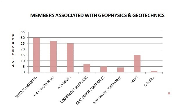
Associations of Geophysics and Geotechnics:
Delft Organization of Geophysics Students
International Union of Geodesy and Geophysics
National Institute of Geophysics and Volcanology
Dallas Geological Society
American Geological Institute
Austin Geological Society
Geological Association at Berkeley
Geological Society of America
ASCE American Society of Civil Engineering
International Society for Soil Mechanics and Geotechnical Engineering
American Rock Mechanics Association
American Society of Civil Engineers GEO Institute
Geotechnical Market:
Worldwide Geotechnical market is relied upon to profit altogether over the estimate time frame inferable from rising interest for non-private development extends that require generally thoughtful architects. Common is a building that primarily frets about the plan, development, and upkeep of the physical and also normally assembled environment. They discover applications in both private and in addition open division. Governments over the globe are concentrating on building up the current foundation and building new ones. Rising weight on governments to give better enhancements, network, and essential foundation have expanded open spending on zones, for example, streets, parkways, and dams. These exercises require broad arranging and watchful execution from their origin to finish. Structural Engineering takes into account this need. This ascent in administrative spending is relied upon to decidedly profit the worldwide structural building industry. Good directions and laws about security and anticipation for risks are demonstrating helpful for the general market. Clients are spending more on arranging and outlining to make development exercises free from the potential dangers. Organizations concentrating more on broadening and development describe the mechanical area. This has expanded the interest for space. In addition, a few components, for example, crude material acquirement, work accessibility, geological nearness and effective dispersion have constrained significant organizations to embrace development of new business plants. This pattern is relied upon to decidedly profit the market development. The private land part will undoubtedly witness fast development because of rising discretionary cashflow and way of life. Quick urbanization, government support and interest for better and available administrations are required to profit the business land segment. The development in private and additionally business land segment have emphatically profited the business in the current past and is required to proceed with the same over the estimate time frame.
Geophysics Marine seismic Market Analysis :
By perusing this investigation you will additionally welcome the reasons why spending on marine seismic hardware and securing is relied upon to fall essentially in 2015 after the oil value fall and after that step by step recoup in accordance with oil costs. Nonetheless it will take numerous years to achieve CAPEX levels seen in 2014. In any case, what will keep on driving the business sectors going ahead is the need to meet future constancy challenges, developing vitality request and recouping oil costs.
Market scope:
Our meaning of the marine seismic market separates the segment into two discrete market spaces Equipment and Acquisition.
Hardware alludes to CAPEX spent on gear used to acquire seismic information in the marine setting. The different sorts of seismic gear included inside this report are: 2D seismic vessels, 3D seismic vessels, moves up to existing seismic vessels, source clusters and source coordination frameworks. 4C gear, Permanent Reservoir Monitoring (PRM) hardware and establishment, information handling abilities on-board a wide range of recording vessel and route hardware.
Securing incorporates the cost of getting and acquiring seismic information in the marine environment. There are three sorts of cost: The cost of paying a seismic vessel administrator to accumulate seismic information seaward for exclusive purposes, The cost of paying a seismic vessel administrator to gather seismic information seaward for multi-customer library purposes, the OPEX of directing an overview for the seismic administrator who expects to add the information procured to its own multi-customer library available to be purchased to intrigued customers and organizations. If it's not too much trouble take note of that offers of multi-customer information are excluded inside this market figure.
The Marine Seismic Equipment and Acquisition Markets 2015-2025 report showcase knowledge.
- 123 tables, outlines, and diagrams uncover the market information and patterns permitting you to focus on your procedure all the more successfully.
- The marine seismic market develop is Global, territorial and marine seismic submarket conjectures and examination from 2015-2025
- The marine seismic market Evolve. See a specialist meet with a key assessment pioneer examining the elements.
- EMGS ASA
submarkets will thrive from 2015-2025
- 3D Seismic Vessels and Equipment 2015-2025.
- Seismic Streamers and Associated Command and Control Systems 2015-2025.
- 4C Seismic Equipment 2015-2025.
- Seismic Sources and Associated Coordination Systems 2015-2025.
- 2D Seismic Vessels and Equipment 2015-2025.
• Here marine seismic obtaining submarkets will flourish from 2015-2025
- Multi-Client Seismic Acquisition
- Proprietary Seismic Acquisition
- 3D Seismic Acquisition (3D, 4D, WAZ)
- Ocean Bottom Seismic (OBS) Acquisition ( 3C, 4C, PRM) - 2D Seismic Acquisition
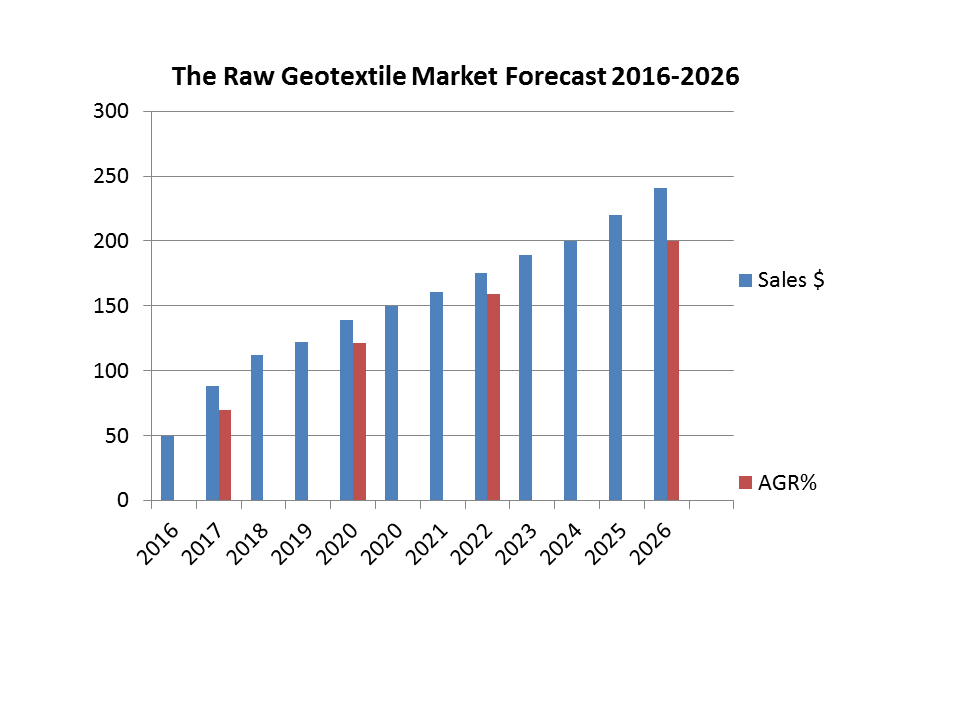
The Raw Geotextile Market Forecast 2016-2026:
Geotextiles are part of the geosynthetic group of materials which include geogrids, geomembranes, geopipes, geocomposites, geosynthetic clay liners, and geonets. A wide range of sectors have used geotextiles since 1950. The first geotextiles were woven industrial fabrics. Initially, they were used for waterfront structures, then the first nonwoven geotextiles for construction purposes were developed.
Visiongain calculates the global geotextile market is worth $5.5bn in 2016. China and the US are the biggest markets, each with a significant share in 2016. These are followed by the Indian and Japanese markets.. Russia, China and Japan have the most dynamic growth among the national markets, although this varies by process and application.
Visiongain’s report reveals where these market growth opportunities are, keeping you informed and ahead of your competitors. Gain that competitive advantage.
• The study reveals the geotextile market forecast by leading national markets from 2016 to 2026:
- Chinese Geotextile Market 2016-2026
- United States of America Geotextile Market 2016-2026
- Indian Geotextile Market 2016-2026
- Japanese Geotextile Market 2016-2026
- Russian Geotextile Market 2016-2026
- Italian Geotextile Market 2016-2026
- Denmark Geotextile Market 2016-2026
- Netherlands Geotextile Market 2016-2026
- UK Geotextile Market 2016-2026
- German Geotextile Market 2016-2026
- Brazilian Geotextile Market 2016-2026
- United Arab Emirates (UAE) Geotextile Market 2016-2026
- RoW Geotextile Market Forecast 2016-2026
• Overview also forecasts geotextile applications from 2016 to 2026:
- Road Construction Submarket Forecast 2016-2026
- Waste and Landfill Submarket Forecast 2016-2026
- Water Construction Submarket Forecast 2016-2026
- Other Applications Submarket Forecast 2016-2026
• Overview also forecasts geotextile manufacturing process submarkets from 2016 to 2026:
- Nonwoven Manufacturing Process Submarket Forecast 2016-2026
- Woven Manufacturing Process Submarket Forecast 2016-2026
- Knitted Manufacturing Process Submarket Forecast 2016-2026
• Overview also forecasts geotextile material submarkets from 2016 to 2026:
- Polypropylene Submarket 2016-2026
- Polyethylene Submarket 2016-2026
- Polyester Submarket Forecast 2016-2026
Benefit from this report:
• Enhance your strategic decision making
• Full understanding and potential business opportunities in the geotextiles market
• Show which emerging market opportunities to focus upon.
• Increase your Industry knowledge and positioning in the geotextiles market
• Run a successfully a new marketing strategy
• Build new partnerships available in the geotextiles market
• Keep you up to date with crucial geotextiles market developments and issues
• Allow you to develop informed growth strategies
• Build your technical and management market insight
• Illustrate trends to develop new business opportunities
• Strengthen your analysis of competitors’ innovation and its market penetration.
• Provide risk analysis, helping you avoid the pitfalls other companies could make
• Ultimately. Engage effectively your internal and external stakeholders.